Truro (Truro)
 |
 |
The area has been home to the Mi'kmaq people for several centuries. The Mi'kmaq name for the Truro area, "Wagobagitik" means "end of the water's flow". Mi'kmaq people continue to live in the area at the Millbrook and Truro reserves of the Millbrook – We’kopekwitk band.
Acadian settlers came to this area in the early 1700s. The Mi'kmaq name for the Truro area was shortened by the settlers to "Cobequid", and the bay to the west of the town is still named Cobequid Bay. By 1727, the settlers had established a small village near the present downtown site of Truro known as "Vil Bois Brule" (Village in the burnt wood). Many Acadians in this region left in the Acadian Exodus which preceded the Expulsion of the Acadians in 1755. In 1761, the British settled the area with Presbyterians of predominantly Ulster Scottish origin who came from Ireland via New England. They named the new settlement after the city of Truro in Cornwall, United Kingdom.
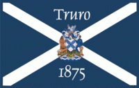
Originally a small farming community, the construction of the Nova Scotia Railway between Halifax, and Pictou in 1858 caused the municipality to experience a fast rate of growth which increased even more when the railway connected to central Canada in 1872 and became the Intercolonial Railway. The Intercolonial, which later became the Canadian National Railway built a large roundhouse and rail yard in Truro. Further rail links to Cape Breton and to the Annapolis Valley through the Dominion Atlantic Railway in 1905 increased the town's importance as a transportation hub for Nova Scotia. The railway also attracted industries such as the Truro Woolen Mills in 1870 (which later became Stanfield's) and provincial institutions like the provincial Normal School (later the Nova Scotia Teachers College) and the Nova Scotia Agricultural College. The town officially incorporated in 1875. Many figures from the town's past were featured in over 40 tree sculptures which were carved in tree trunks after Truro lost most of its Elm trees to Dutch Elm Disease in the 1990s. As of 2018, most of these sculptures were suffering from severe deterioration and were taken down. The history of the town and surrounding county is preserved at the Colchester Historical Museum (c.1900-1901), which is designated under the provincial Heritage Property Act.
Map - Truro (Truro)
Map


Country - Canada
 |
 |
| Flag of Canada | |
Indigenous peoples have continuously inhabited what is now Canada for thousands of years. Beginning in the 16th century, British and French expeditions explored and later settled along the Atlantic coast. As a consequence of various armed conflicts, France ceded nearly all of its colonies in North America in 1763. In 1867, with the union of three British North American colonies through Confederation, Canada was formed as a federal dominion of four provinces. This began an accretion of provinces and territories and a process of increasing autonomy from the United Kingdom. This widening autonomy was highlighted by the Statute of Westminster 1931 and culminated in the Canada Act 1982, which severed the vestiges of legal dependence on the Parliament of the United Kingdom.
Currency / Language
| ISO | Currency | Symbol | Significant figures |
|---|---|---|---|
| CAD | Canadian dollar | $ | 2 |
| ISO | Language |
|---|---|
| EN | English language |
| FR | French language |
| IU | Inuktitut |